Josaphat
Transforming a landlocked railway site into a vibrant neighbourhood
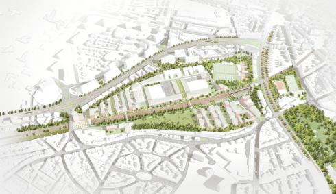
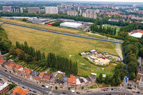
The Josaphat site, located on the boundary between Schaerbeek and Evere, partly corresponds to a former railway marshalling yard commissioned in 1926 and operated until 1994, when its activities ceased. Following its decommissioning, this 22-hectare site—one of the last remaining regional land reserves—was acquired by the Brussels-Capital Region through the SAU.
The site extends on both sides of the railway tracks: around 10 hectares lie to the west, while the remaining 12 hectares stretch to the east. This eastern section hosts an urban industry zone, still in operation, as well as sports facilities.
Revitalising the urban industry zone
On the eastern side of the railway tracks, the urban industry zone is undergoing a project to modernise and densify its central area. In 2024, the SAU transferred its management to Citydev, which works closely with the companies operating on the site. In 2025, two of these companies submitted planning applications to build and/or expand their facilities.
Utility networks and public spaces within the urban industry zone will be redeveloped. The preliminary design is currently being prepared under the project management of Beliris. The planning application is expected to be submitted by the end of 2026.
Maintaining sports facilities
The sports facilities are located in the south-eastern part of the site. On regional land, this includes the Set Wahis tennis club, a family-run business renowned for the quality of its youth training and high-level player development.
Creating a new sustainable neighbourhood
On the south-western side of the railway tracks, the Government of the Brussels-Capital Region entrusted the SAU in 2016 with launching a joint tender with public housing companies to urbanise part of the site. This initiative marked the start of an innovative and complex “competitive dialogue” procedure.
Alongside protected areas dedicated to biodiversity, the project aims to develop a new sustainable neighbourhood. It will include publicly accessible green spaces, a mix of housing types, local shops, and facilities such as a school and a nursery, as well as small spaces for professional activities. The project is designed to be exemplary in environmental terms, with standards exceeding regional requirements.
The creation of new green spaces in an area partially lacking them will provide residents of Schaerbeek and Evere with places for relaxation and social interaction.
Led by the Eiffage/AXA consortium, the project предусматривает the construction of 509 housing units, of which 52% will be public housing: 135 social rental units (27%), 23 moderate-income ownership units on separated land ownership (4%), and 105 subsidised middle-income units on separated land ownership (25%).
The subdivision permit application is currently under review.
Balancing urban development and nature protection
At the time of its acquisition, the site had low environmental quality. Its partial remediation by SNCB and the planting of a wildflower meadow by the SAU have helped transform it into what we see today.
Biodiversity lies at the heart of the project. The subdivision permit proposal not only ensures the preservation of a significant portion of the site but also includes numerous features within the urbanised areas to support biodiversity.
All developed surfaces—both buildings and roads—will incorporate integrated stormwater management, ensuring zero discharge of rainwater into the sewer system, even during extreme rainfall events. This will be achieved through the creation of wetlands (ponds and infiltration swales), promoting diverse flora and fauna, as well as permeable road surfaces.
All planted species will be native, and green spaces will be managed to protect existing wildlife, particularly insects. Adjustable public lighting will limit light pollution to protect bats present on the site. The use of recycled and ecological materials will reduce the project’s carbon footprint. Buildings and their surroundings will also include features to accommodate nesting, breeding, and sheltering species.
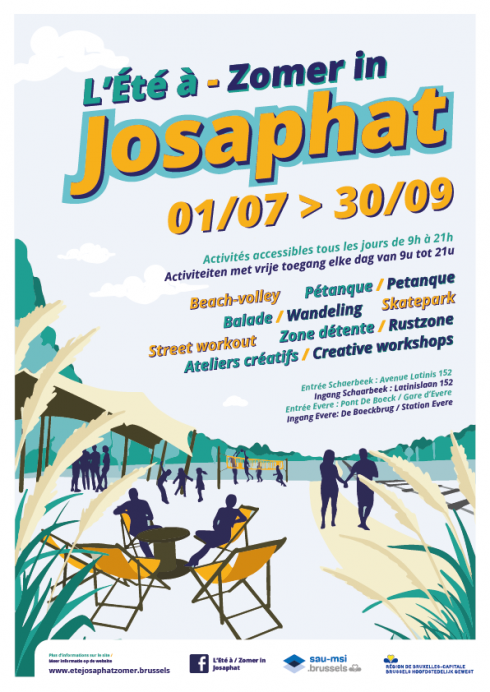
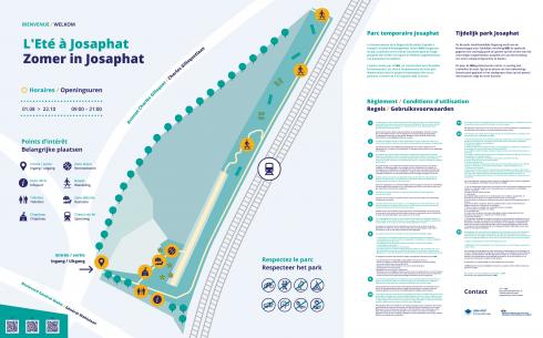
Temporary uses to activate the site
Pending the implementation of long-term projects, the SAU supports temporary uses of the site by making land available to residents and local collectives. These groups develop community gardens, sports activities, and nature observation walks. The site is also occasionally opened to various audiences, including students wishing to explore the area and the project.
These initiatives help bring life to and secure a site that is otherwise highly enclosed due to its geographical configuration.
Did you know?
Competitive dialogue is particularly suited to large-scale or innovative projects where solutions are not standardised. It is a public procurement procedure that allows contracting authorities to engage in dialogue with several selected candidates before finalising the specifications. It fosters optimised solutions through exchanges with candidates and ensures better consideration of technical, economic, and legal constraints prior to contract award. More flexible than traditional procedures, it allows adaptation to evolving planning contexts.
Role of the SAU
The SAU operates at two levels in the development of the Josaphat site: on the one hand, it develops integrated urbanisation projects in partnership with public housing operators; on the other, it coordinates, facilitates, and, where necessary, supports the various public authorities involved in the site in their respective roles.
Partners
Citydev, SLRB, Housing Fund, Eiffage-AXA, Beliris, Municipality of Schaerbeek
Key figures
130,600 m² — Open spaces accessible to the public or reserved for biodiversity
42,740 m² — Land dedicated to urban industry
48,913 m² — Land dedicated to sports and educational facilities
15,400 m² — Floor area for offices, retail and hospitality
Project managers
- Juana BASTOS